|
|
|||
|
|
|
||
|
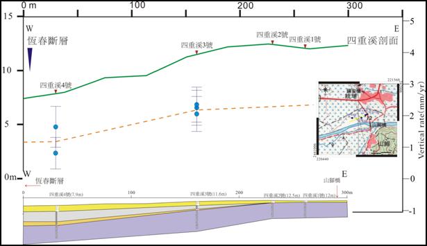
Both sides of the bedrocks show the Kenting Formation on the Shichung River site core-analysis as expected. The vertical deformation rate estimated from the three dating of Sichung River borehole 3 (located on the west of the Sichung River) are respectively: 2.0±0.16 mm/yr (7590-7950 yr BP), 2.4±0.6 mm/yr (7970-7790 yr BP), and 2.3±0.6 mm/yr (8050-7140 yr BP). The vertical deformation rate estimated from the two dating of Sichung River borehole 4 are 0.8±0.5 mm/yr (7420-7250 yr BP), 1.7±0.7 mm/yr (8390-8200 yr BP). Obviously, Sichung River borehole 3 and 4 are both located on a lifted environment, this research perceives that the Hengchun Fault is located on the west of the Sichung River borehole 4.
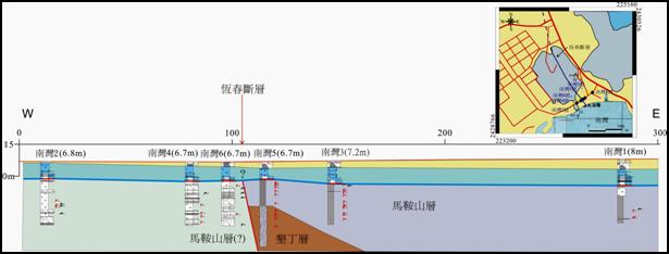
Judging from the borehole core analysis of the Nanwan site, the Kenting formation of the Nanwan Borehole 5 and 6 thrust upon the Maanshan Formation caused the stratohorizon difference of the two sides of the Maanshan Formation. Thus, the fault is estimated to locate between the Nanwan Borehole 5 and 6.
Wenshan Chen et al. (2005) utilized the borehole data of late Pleistocene limestone outcrop in Hengchuen Valley to draw a subsidiary fault on the west of the southern section of the Hengchuen Fault. Bochuen Chen and Chuanyao Ju (2010) further extended the drawn fault northwards. However, judging from the geological analysis, no obvious terrain structure of an active fault is shown along the subsidiary fault (Hengchuen Valley). According to the Haikou borehole data analysis from Wenshan Chen et al. (2006), the west of the Hengchen Fault is in subsidence, and no apparent evidence of an active fault (thrust fault) is shown. This research perceives that according to the current terrain data analysis, the Hengchuen Fault, which has been active since Holocene, should locate on the presently apparent terrain scarp, for example, from Haikou to Sichung River. The southern section is approximately located on the intersection of the rim of the foothills and the Hengchuen Valley towards the Nanwan area, along Maanshan, or the east side, extending southwards to the Nuclear 3 outlet into the Nanwan ocean area.
Although the borehole on Sichung River and Nanwan can locate the fault covered by the Holocene alluvium, according to the previous research, when the Hengchuen Fault cuts to the Kenting Formation, subsidiary faults could thus develop. The more active faults during the Holocene are cut within the Kenting Formation (Wenshan Chen, 2006; Pochuen Chen and Chuanyao Ji, 2010) Thus, it is still up for discussion whether the fault between Nanwan borehole 5 and 6 in the Nanwan site belongs to the active faults in Holocene.
The vertical deformation rate of the Hengchuen Fault can be thus calculated comparing the 14C dating data of the sea-terrace coral debris collected from the Nanwan borehole and the 14C dating data of the coral reef terrace in the adjacent area.
The vertical deformation rate of the Nanwan Borehole 1 is 0.1±0.2 mm/yr (3690-3420 yr BP), -0.9±0.1 mm/yr (4960-4880 yr BP). The vertical deformation rate of the Nanwan Borehole 2 is 2.2±0.4mm/yr (2680-2320 yr BP), 0.8±0.1mm/yr (2110-1820 yr BP). The vertical deformation rate of the Nanwan Borehole 3 is 0.2±0.3 mm/yr (4140-3850 yr BP). The vertical deformation rate of the Nanwan Borehole 4 is 0.6±0.3mm/yr (2740-2330 yr BP), -0.2±0.0mm/yr (1870-1580 yr BP). The vertical deformation rate of the Nanwan Borehole 5 is 2.6±0.2mm/yr (1330-1130 yr BP), -0.3±0.2mm/yr (3060-2750 yr BP). The vertical deformation rate of the Nanwan Borehole 6 is 1.9±0.3mm/yr (1890-1610 yr BP), -0.5±0.3mm/yr (2590-2280 yr BP). The estimated vertical deformation rate shows almost no variation, or only a slight subsidence. Besides, the coral reef dating data collected from the Nanwan Nuclear 3 coast is 2700-2380 yr BP (0 m altitude), 7150-6870 yr BP (0 m altitude). From the estimated long term vertical deformation rate of the Nanwan sea-terrace dating, no sign of variation is shown. The coral reef dating data collected from the Houbi Lake coast is 1950-1770 yr BP (0 m altitude, sea-terrace height 2 m), the estimated lift rate is 1±0.1 mm/yr. The date of the coral debris collected from the Houbi Lake coast is 1600-1380 yr BP (5 m altitude), the estimated lift rate is 3.4±0.3 mm/yr. The long-term vertical deformation rate collected from Nuclear 3 and the Nanwan area, which is near to the fault, has no sign of difference. The long-term vertical deformation rate collected from west-side sea-terrace, which is far from the fault, has an elevation. It is discovered that the western the sea-terrace, the higher the long term vertical deformation rate. This phenomenon is very similar to the terrain surface of the Hengchuen west tableland. Obviously the western area of the Hengchuen Fault is affected by another fault which is located on the ocean area.
Furthermore, calculated from the dating data of the Hengchuen Fault hanging wall (east side) sea-terrace area, the long term vertical deformation rate of the Kenting National Park is >4.3±0.1 mm/yr (7260-7140 yr BP), >4.0±0.1 mm/yr (5440-5180 yr BP), >3.6±0.1 mm/yr (5800-5700 yr BP), >4.2±0.2 mm/yr (4030-3790 yr BP), approximately 4-5 mm/yr. Apparently, the long term vertical deformation rate of the Hengchuen Fault is around 4.2±0.2 mm/yr. From the cross-examination of the profile of Nanwan and the Kenting National Park, an active subsidiary fault might be located on the east of Nanwan Borehole 1. The fault between Nanwan Borehole 5 and 6 should be the main fault of the Hengchuen Fault. Judging from the long term vertical slip rate of Nanwan Borehole 1 and 3, whether the main fault was active during Holocene is still worth discussing. The long term vertical slip rate of the subsidiary fault is about 4.2±0.2 mm/yr.
The profile of the Sichung River Borehole site and the estimated vertical deformation rate of the borehole.
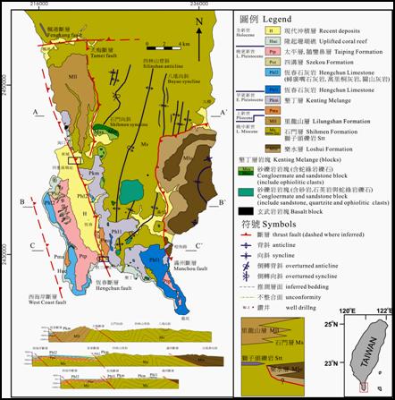
The geological graph of the Hengchuen Peninsula and the location of the Sichung River and the Nanwan Site.
The Nanwan Site Borehole Profile
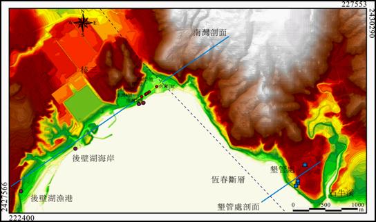
The Nanwan Borehole and the sea-terrace dating sample location.
The Nanwan Site, two sides of the Hengchuen Fault Borehole and the vertical deformation Rate calculated from the sea-terrace.
|
|||