|
|
|||
|
|
|
||
|
The profile on the Tongtou Bridge on Road 149 is a subhorizontal terrace conglomerate layer which unconformably covers on the Pliocene Dawo Sandstone and the Pleistocene Toukeshan Formation. The surface rupture belt of the 921 Chichi earthquake cuts through the northern of Tongtou Bridge, which offset the Dawo Sandstone and the Lingding terrace. The rupture cuts southward through the alluvial riverbank on the south of the Chingshui River and Tongtou terrace.
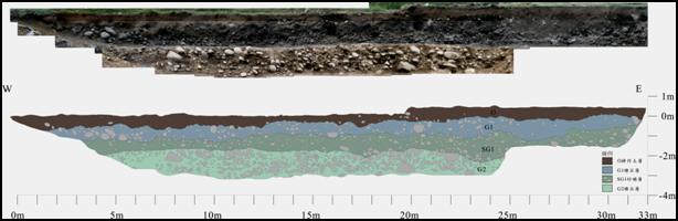
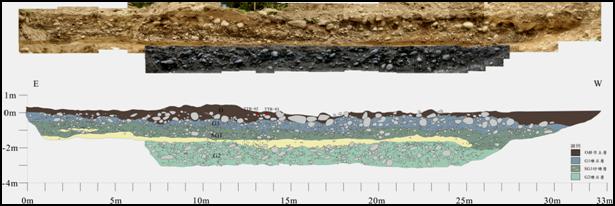
Several shear zones were outcropped on the profile, 9 shear zones were discovered merely in the Lingding terrace. Most of the shear zones have a high-angle shear plane (slanted 60-90 º). Another trench excavation of this research takes place on the west of the southern end of the Tongtou Bridge, which is also the river terrace of the Chingshui River. The 921 Chichi Earthquake caused the Tongtou Bridge to break, the surface deformed and uplifted about 30 cm, the drain also ruptured and offset 50 cm. The location of the surface uplift was undeterminable. Herein, the trenching site takes the 921 surface rupture scatter diagram for reference. The trench profile has not discovered any tectonic deformation of the stratum. The stratum is still horizontal sediment, and no structural de3formation has been discovered in the trench profile. However, sandstone layer on the east side of the southern wall profile has about 20 cm of height difference. Though site is located via the GPS data from the Geological Survey after the ChiChi Earthquake, it is still undeterminable whether the difference is caused by the 921 ChiChi Earthquake. Evidences of partial artificial destruction have also been discovered through field investigation. This study perceives that the fault trace runs across this fault trace and caused only 20cm of deformation, the sandstone layer has not been cut off. This phenomenon matches the investigation results previously collected; the vertical deformation was only tens of centimeters.
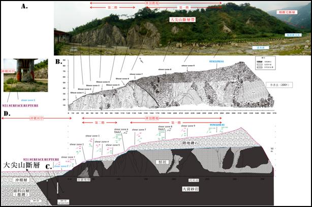
The profile of Putou Bridge: (A) the profile picture of May, 2010; (B) Profile-sketch (Yienliang Li, 2001); (C) Geological Profile (The borehole data is edited from Shih Ting Lu et al., 2003)
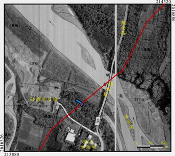
The trench excavation location of the Dajianshan Fault. Marked red is the fault trace of the 921 ChiChi Earthquake. (TWD67)
The north wall profile of the Tongtou Bridge trench.
The south wall profile of the Tongtou Bridge trench.
|
|||