|
|
|||||||||||||
|
|
||||||||||||
|
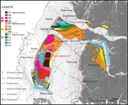
1, Regional Geology
The
Tachia fault is a frontal thrust fault in the central Taiwan that formed
most recently. The deformation along the fault ramp that formed the Tatu
anticline, geographically formed the Tatu tableland
(Figure 1).
But the fault trace has not found, the previous studies speculated that
it is situated at the frontal scarp on the western tableland. Moreover,
there have been still different views whether the Tachia fault is a
blind fault or not. Based on the boring log of DC-1 and DC-2 cores on
both sides of the fault, it appeared that the Tachia fault has cut
through the ground surface. The strata on both sides of anticline shows
a gentler dip on the eastward limb about 6º and more steep on westward
limb about 10º, but the dip near the fault tip revealed westward tilt
about 50-60º. Based on the structural features, the Toukoshan Formation
on the fault tip suddenly displaying high angle may have to speculate
that the fault tip cut through the surface.
Analysing
from the aerial photo and DTM data, the Tatu and Houli tableland can be
divided into 13 level terraces which were formed by the Taan, Tachia and
Tatu rivers (Figure 1). During the Late
Pleistocene, the uplifting tableland along the thrust front that was
eroded by the three rivers and formed a complex river terrace group. H
and M lateritic terrace is the older terrace, H1 terrace is the oldest
terrace is represented the Initially depositional surface of the Tatu
tableland. The lateritic terrace formed a warping surface, and the
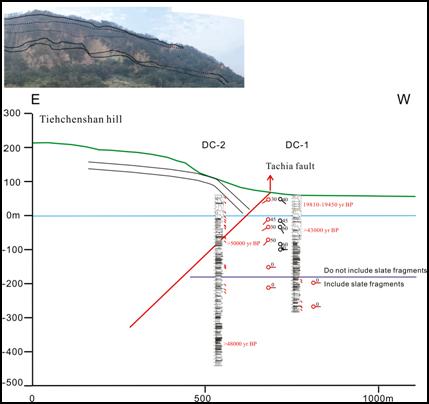
non-lateritic terrace (L terrace) only showed an eastward titling. 2, Fault Character Based on the borehole longing of DC-1 and DC-2, the DC-1 borehole on the footwall of the Tachia fault shows a few of horizontal shear zones in 250-340 m deep. In comparison, the DC-2 borehole reveals more complex features that the bedding-plane above 157 m deep appears about 40-60º and nearly horizontal below 157 m deep (Figure 2). The shear-plane dip above 150 m deep is at 30-50º; and it is nearly horizontal below that. Based on the structural features, it is assumed the Tachia fault is located at the 157 m deep of the DC-2.
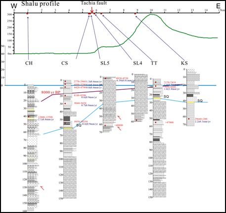
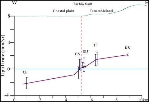
In addition, several boreholes along the Tachia fault including the Houlong (HL), Sankuang (SK), Chingshui (CS), Chungho (CH), Tatu (TT), and Kuosheng (KS) wells, we therefore use the paleoenvironmental depth, paleosea-level elevation and 14C dating to estimate the tectonic deformation rate of the Tachia Fault. The Chngho (CH) and Chingshui (CS) wells are located on the footwall that the subsidence rate is about 1.3-2.9 mm/yr, the Kuosheng (KS) and Tatu (TT) wells are on the hanging wall that the uplift rate is about 2.1-2.3 and 0.5-2.6 mm/yr, respectively (Figures 3 and 4). The vertical deformation rate on both sides of Tachia fault represents the deformation rate of each drilling site relatively to a datum surface of the sea-level, the slip rate should be the relative crust deformation rate on both sides of the fault. Therefore, the Tachia fault vertical slip rate should be 1.7-6.5 mm / yr.
|
|||||||||||||