|
|
|||||||||||
|
|
||||||||||
|
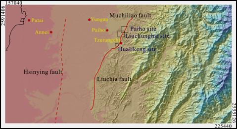
The Muchiliao Fault-Liuchia Fault is a frontal fault located on the southwestern foothills fault which stretches southwards from Pachang River to Tsengwen River. (Figure 1) According to the field investigation conducted by this research, the Muchilioa Fault was possibly a hundreds-meter-wide deformation band which consists of several faults. It may also be a trishear zone deformation structure created by the shallow-layered sedimentary formation on the near-surface front rim of the fault. The borehole investigation (Tzutungchi) also shows that the Liushuang Formation on the hanging wall has a bigger offset along the major shear surface, and thrusts on the late-Pleistocene sedimentary formation. The thrust causes a small shear zone (the core usually possesses shear zone structures) in the front rim of the major fault, thus becoming an upheaval terrain. (Figure 2; Yang et al, 2007; C.C. Barry Yang et all, 2005) This study has chosen two sites – the Paiho Site and the Liuchunghsi Site to proceed with a shallow layer core-boring. (Figure 1)
Figure 1: The location of the Muchilioa Fault and the Liuchia Fault.
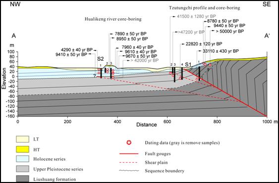
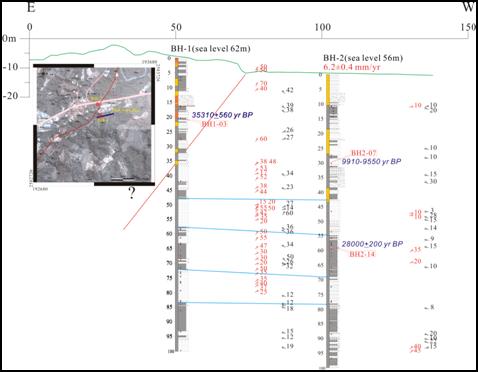
Figure 2: The profile of the Tzutungchi, including the Tzutungchi core-boring and the Hualikeng River core-boring. The Paiho site shows that the upper core of the Paiho core 1 on the hanging wall is older than that of the Paiho core 2 on the foot wall, thus the Muchilioa Fault should be in between two boreholes. Judging from the denseness of the shear structure of core 1, the main offset could be located between 35-55 meters deep. To calculate the uplift rate from the dating and paleo-environment of core 2, the rate has been 6.2±0.4 mm/yr since Holocene. Sue to the fact that there are still no dating data on the hanging wall, the uplift rate cannot yet be calculated. (Figure 3)
Figure 3: The profile and location of the Paiho core-boring.
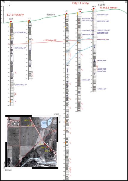
The Liuchunghsi site shows that shear structure exists in all 5 cores. Obviously, this flexture scarp is a deformation terrain affected by the tectonism. The uplift rates calculated from the 14C dating are: 6.1±2.5 mm/yr (Paiho 3), 7.8±1.1 mm/yr (Paiho 4), and 5.7±0.4 mm/yr (Paiho 5).
Figure 4: The profile and location of the Liuchunghsi core-boring.
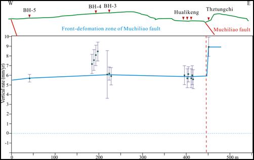
Judging from the Liuchunghsi Site, Paiho Site, and Hualikeng Site (2006, lift rate: 5.9±1.0 mm/yr), the uplift rate is approximately the same, and has an average of 6.1±1.3 mm/yr. Previously, this research has estimated the uplift rate of 9.0±1.0 mm/yr on the Tzutungchi area (1 kilometer south to the Liuchunghsi Site) on the hanging wall of the fault. Obviously the upheaval terrain in front rim of the foothills are related to the affect of the Muchiliao Fault. This study believs that the tip of the Muchilioa Fault has cut through the surface (the Holocene sediment has a dense shear structure.)
Figure 5: The uplift rate distribution of the Muchiliao Fault.
|
|||||||||||