|
|
|||||||||||||
|
|
||||||||||||
|
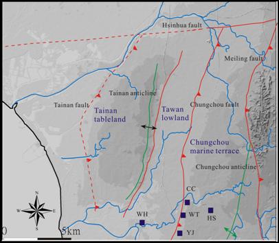
1, Regional Geology The study area is a ongoing deformation front which is dominated by a NE-SW trending structure fabric that consist of three active thrust faults. The geomorphic expression, which preserves a young surface features, is made up of three topographic and structural provinces of the Chungchou Marine Terrace, Tawan Lowland, and Tainan Tableland from east to west (Figuew 1). The geomorphic surface is deposited by poorly indurated Holocene shallow marine sediments which unconformably overlie on the late Pleistocene bedrock. Holocene marine sediments, ranging in thickness from several tens meters to hundreds meters, subsequently cover the three provinces. Based on the boreholes, thick of Holocene sediments are highly variable which represents a poorly known control on the deformation character and old geomorphic surface. The Chungchou fault is bounded between Chungchou marine terrace and the Tawan lowland, that marine terrace consist of the Holocene marine sediments which unconformably overlain on the late Pleistocene formation. The Chungchou marine terrace province formed a westward dip surface which collected from a series of NE trending gentle fault scarps bounded between the Tawan Lowland and Chungchou Marine Terrace provinces (Figure 1), that the scarp is displaced by the Chungchou fault. Scarps range in height from 2 to 5 meters, and a part of scarps are not well exposed where they eroded by the creeks that flow perpendicular to the fault trace.
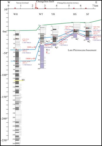
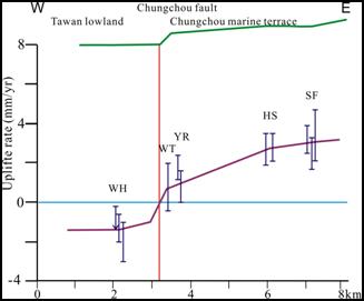
2, Fault Character The Chungchou fault shows a west-verging thrust fault which is bounded between the Tawan lowland and Chungchou marine terrace. The relationship on both sides of the fault shows that the late Pleistocene of the Liushuang Formation is overthrust on the Holocene marine sediments. Based on the 14C dating and paleoenvironment, it can be estimated the vertical deformation rate. Four core-borings on the hanging wall of the Shalun farm (SF), Tainan high-speed raid station (HS), Yiren (YR), and Wutung (WT) wells, the uplift rate is estimated at 1.2-4.7mm/yr (Figures 2 and 3). The Wenhsien (WH) well on the footwall that the subsidence rate is 0.4-3.0 mm/yr. As a result, it is estimated that the vertical slip rate of the Chungchou fault is about 1.6-7.7 mm/yr.
|
|||||||||||||