|
|
||||||||||||
|
|
|||||||||||
|
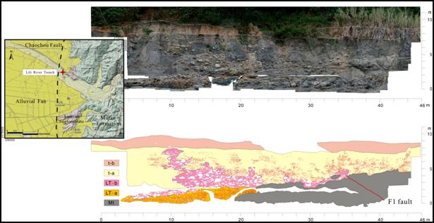
Chaochou fault outcrops from Fangliao in the south and northward to
Baolai. It’s the major structural boundary between the low grade
metamorphic Central Range domain and Western Foothill domain. In its
south part, the range bound with Pintung Plain and the channel in the
range (hanging wall) side form a “drowned valley” which suggest the
sedimentary rate in the footwall is higher than the uplift rate in the
hanging wall. This study we observe a fault cut through the Mutan Fm,
and offset the overlying gravel bed. From the Lili River no.1 borehole
data, the basement is in the depth of 42.75-150 m, it suggests the
faulting in the Lili River might be a branch fault. For deciphering the
stratigraphic relations and the faulting events, we trench and cleaning
a 46 m long and 10 m high profile.
The
profile situates in the western margin of the range (figure.1), there
are 2 terraces with different level in the north bank of Lili River. The
higher one is a lateritic terrace gently dips to the west. The lower one
is a recent river terrace. In the bottom of the profile, the low grade
metamorphic argillite basement (Mt) outcrops. The bedding attitude is N8oE,45oE.
A clast supporting, well sorted, and weakly weathered gravel bed (LT-a)
unconformibly overlies on the basement but it doesn’t display .any
displacement. Another gravel bed (LT-b) shows poor sorted, matrix
supporting, and well cementation overlies on LT-a. Its matrix has been
laterized and always present in brown color. LT-b conformably deposit on
LT-a in some part and unconformibly overlie on Mt. Gravel bed t-a which
is loosely cemented, well sorted, and clast supporting, interfingers
with LT-b, but it displays unconformable with LT-b in the downstream
site. We suggest this phenomenon is caused by lateral erosion of the
channel but not by faulting. In the top of t-a, a lateritic, poor
sorted, and matrix supporting gravel bed (t-b) cap on it. It shows bad
lateral extending and the thickness is not uniform along the profile. So
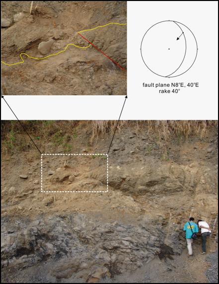
we infer this t-b bed as a re-deposited lateritic gravel bed. The fault F1 in the profile cutting through the basement, and it’s attitude is N8oE/40oE (figure. 2), lineation of the shear plane displays a thrust with left-lateral shear sense. The bottom of LT-b has offsetted probably larger than 35 cm, but the recent terrace (t-a) didn’t show any evidence of faulting. So we conclude that the branch fault of Chaochou fault is active in late Pleistocene, and recent faulting extend to the plain area west to the Lili river borehole site.
Figure.1 Locality of Lili bridge trench site and its profile.
Figure.2 Enlarged photo of fault zone.
|
||||||||||||